Meet the Modelling Team!
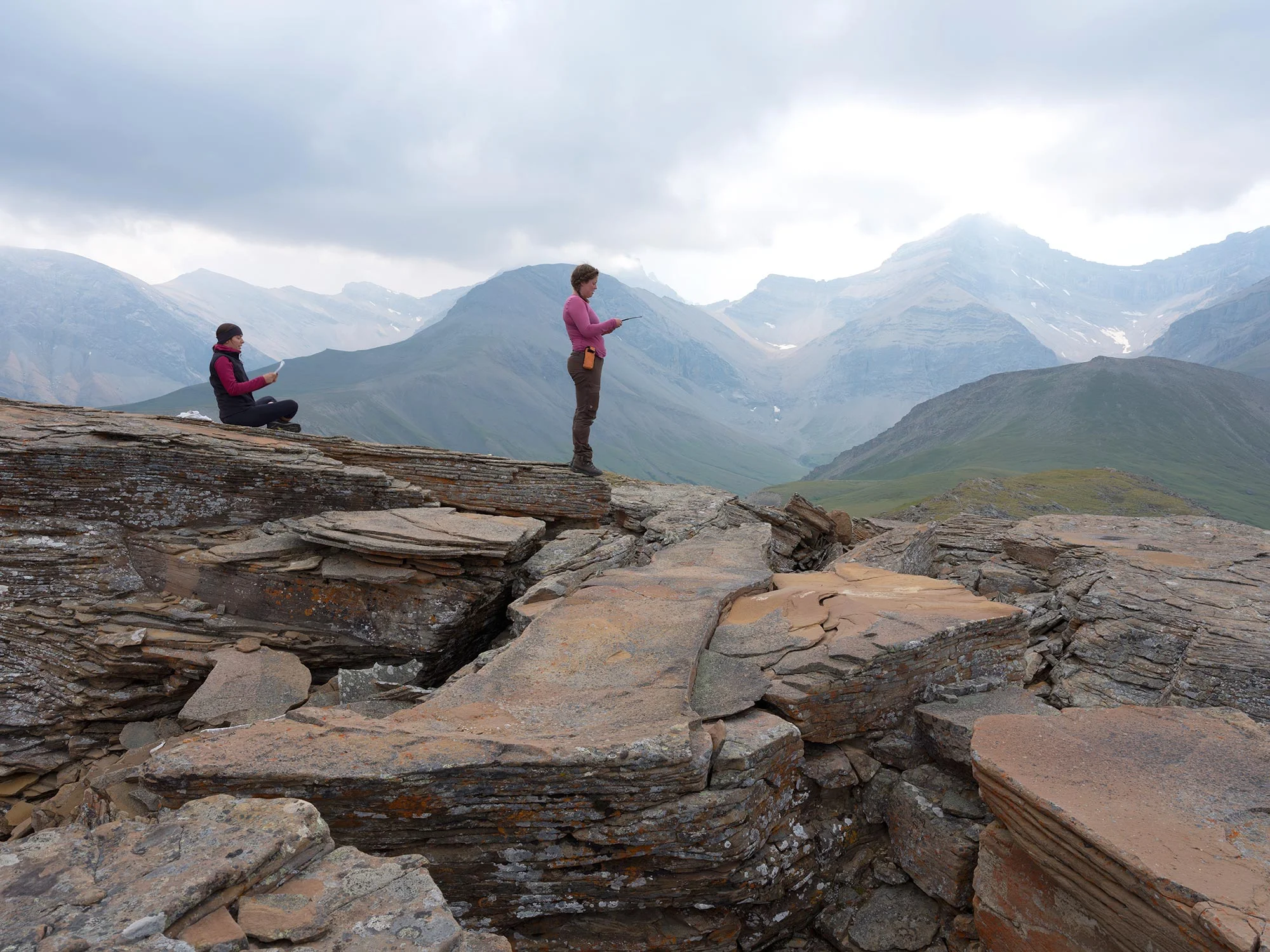
/Our field teams collect a massive amount of data from mountaintops and forests across the Eastern slopes of the Rockies. Because our team has the good fortune of such a big dataset, we can ask questions at a broader scale than a lot of other projects - we are even starting to predict what the future of these landscapes might look like.
When it comes to answering these big scale questions, our Modelling Team is not using their hiking boots: they are using computers.
From the field to the office

Dr. Eliot McIntire, a researcher based at the Canadian Forest Service’s Pacific Forestry Centre in Victoria, BC, leads the Modelling Team. It might surprise you to hear that his career in computer modelling all started with a trip to the woods.
“Much to the chagrin of my city mother, I had a friend whose dad invited me with him[…]to come along on a canoe trip in Killarney Provincial Park in Ontario,” he explained with a laugh. “And my mom did say yes, and we did that for four years in a row. It really just became a part of what I was interested in [in] the world because it was just so fabulous and different from growing up in downtown Toronto.”
Dr. Ceres Barros, a post-doctoral researcher, joined McIntire on the Modelling Team a bit over a year ago. Her motivation to study nature came from a different place.
“Unfortunately, I can’t say this came from growing up surrounded by impressive nature, or in a very natural setting. In fact, my childhood was mostly spent in an urban environment, close to Lisbon, Portugal,” she explained in a previous blog post. “So I blame my Father for having exposed me to the National Geographic TV series and magazines as far back as I can remember, for repeating to me every day that even saving just one toilet paper leaf would help forests, for telling me water is as precious as gold. It is he who taught me to love and respect all things natural.”
You might think that these experiences would push McIntire and Barros out into natural landscapes, bushwhacking and collecting data in the field. But not all aspects of ecological research happen out in the woods: a critical component of the job is tackling the computer work.

“I had a lot of data and I knew people who had a lot of data, and they were just not using it to its fullest,” McIntire said. “Partly because they didn’t have the skills. There is a huge body of expertise related to data analytics.”
For Barros, working with computer models is exciting because of the ambitious, big-picture questions that they can be used to answer.
Dr. Barros hard at work solving modelling challenges! Her current work is focusing on how to predict the severity of wildfires based on variables like vegetation, topography and climate.
“How far can we push ecosystems, which ecosystems are more fragile, which are more resilient, are certain types of disturbances worse than others? These are the sort of questions that get me excited and motivate my work,” she explained.
What are models? Why use them?
You have probably heard the word “model” before, but there are a lot of different contexts that the word can be used in. It is not often intuitive to figure out what researchers mean when they are discussing models.
“To go to an extreme, the fashion industry uses models!” McIntire pointed out. “What are we talking about when we say ‘models’? It just means an abstraction of reality in some way.”
In short, biologists use models to understand patterns that they observe in nature. For example, a researcher might notice that frogs seem to cross the road at night when there is less traffic. It could be that the frogs prefer times with fewer cars on the road, but it is also possible that they prefer to be active during the night, which just happens to coincide with less traffic.
To figure out what might be causing the frogs’ behaviour, the researcher could measure a few different factors (frog activity, traffic, and daylight hours), then begin a modeling process. This process would determine how the behaviour of interest (crossing the road) responds to different combinations of the measured variables. At the end of this exercise, it may turn out that a model including daylight hours does a better job of explaining road crossings than the amount of traffic alone.
“Models don’t necessarily represent the ultimate truth about a system, but they help us understand it better and plan accordingly,” Barros explained.

Dr. Barros taking a core from a tree during fieldwork, which will later be used for tree ring analysis. Spending time in the field is important so that our computation and modeling-focused researchers can put their work in a broader, practical context.
In the frog example, our researcher is trying to understand something about the present. But what if we want to use models to predict the future? For example, the researcher might want to know what would happen to the frogs if a city plan went ahead to widen the road – thus increasing the level of traffic.
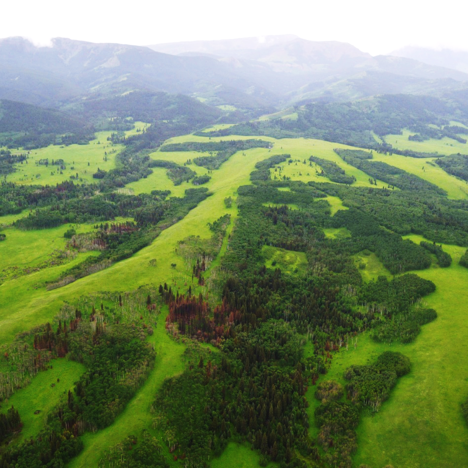
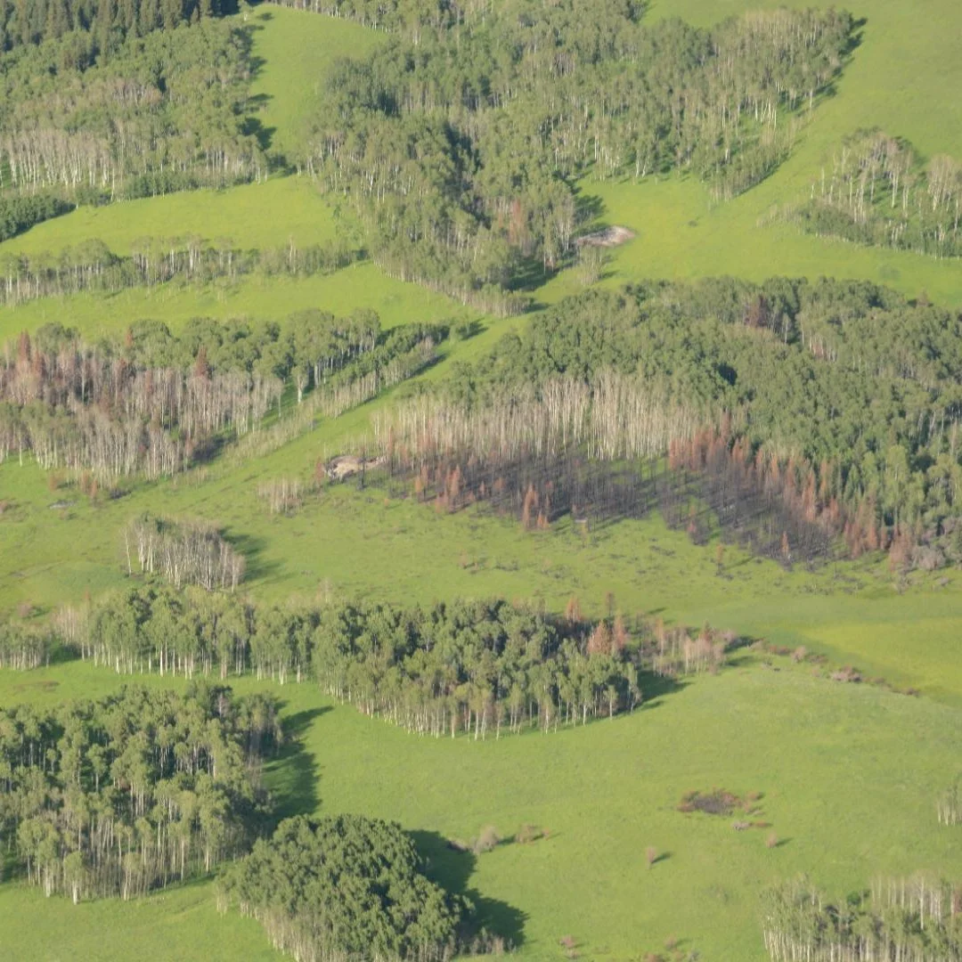
These are the types of predictions that the Modelling Team is trying to make about fires in the Eastern Rockies.
“How are the fires of the future going to impact these landscapes?” McIntire asked. “They’re real landscapes with real people living there, and they have a very real problem that could get out of hand really fast, as it did in many places like Ft. McMurray.”
The future is moving - and models must do the same.
One challenge faced by the Modelling Team is that time doesn’t stand still. The outcome predicted by a model today could change tomorrow if new information came into play. Returning to our frog example, our well-constructed model might not be accurate anymore if a new predator moved into the area and started hunting frogs at night. Perhaps in this case, the frogs would start crossing the road during the day just to survive!
Because conditions are flexible and always changing, McIntire emphasized that models need to constantly adapt to new information.
“One of the things I’m trying to accomplish is to create the same understanding among the non-modellers of the world that people have of weather forecasting,” he explained. “Just because weather stations forecast 14 days in the future doesn’t mean that it’s perfect, and they also don’t stop once they’ve made that forecast. [They] make a 14-day weather forecast every six hours because the future is moving.”
What’s next? Bringing the data to the decisions.
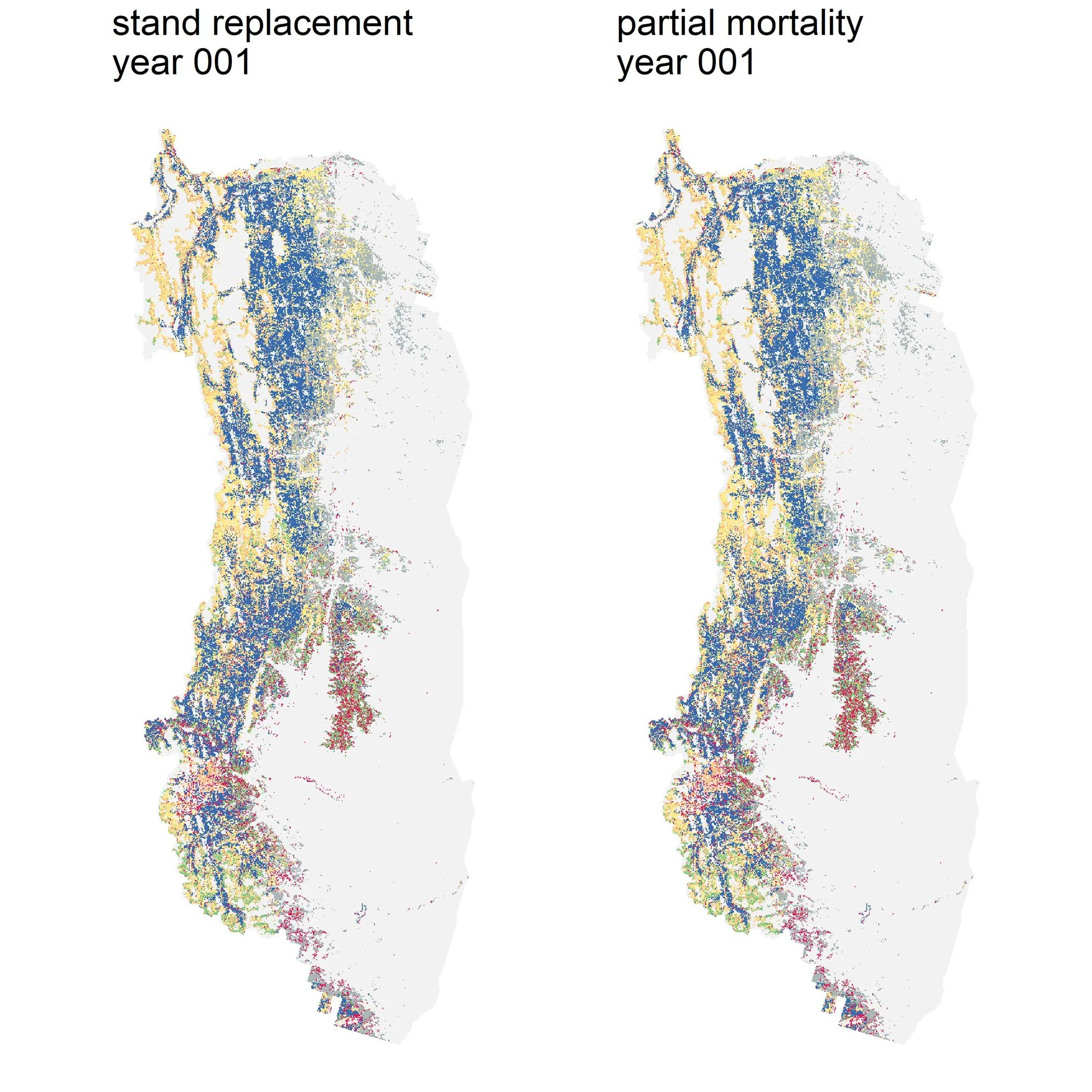
It is clear that our Modelling Team has quite a large job - so, what has been accomplished so far, and what’s coming next? A big part of the work has been getting a better understanding of mixed severity fires: fires that burn at different intensities, including low and moderate burns. Previously, forests in Canada’s Rockies were assumed to be driven by high-intensity, stand-replacing fires.
“In some previous studies, it became fairly clear that ignoring mixed severity fires was being done at our detriment. Forecasts were not clearly matching historical understanding,” McIntire explained. “One of the major studies we’re just wrapping up[…]showed that our answers are not quite right and this is why.”

In the near future, the Modelling Team will begin the task of forecasting the future based on the Landscapes In Motion dataset. In the long term, McIntire and Barros are hopeful that this work will help land managers make decisions at a broader scale to ensure that fire and people can co-exist sustainably together.
“We’ll be able to do things like: with and without climate change, what are the forecasts for this area? With and without mixed severity?” McIntire said. “It’s really about building the scenarios that we can show to people and talk about decisions that we want to make based on these scenarios. It’s the applications that are next.”
Every member of our team sees the world a little bit differently, which is one of the strengths of this project. Each blog posted to the Landscapes in Motion website represents the personal experiences, perspectives, and opinions of the author(s) and not of the team, project, or Healthy Landscapes Program.